27 x 2027
What is the 27 x 2027 Urban Mobility Network?
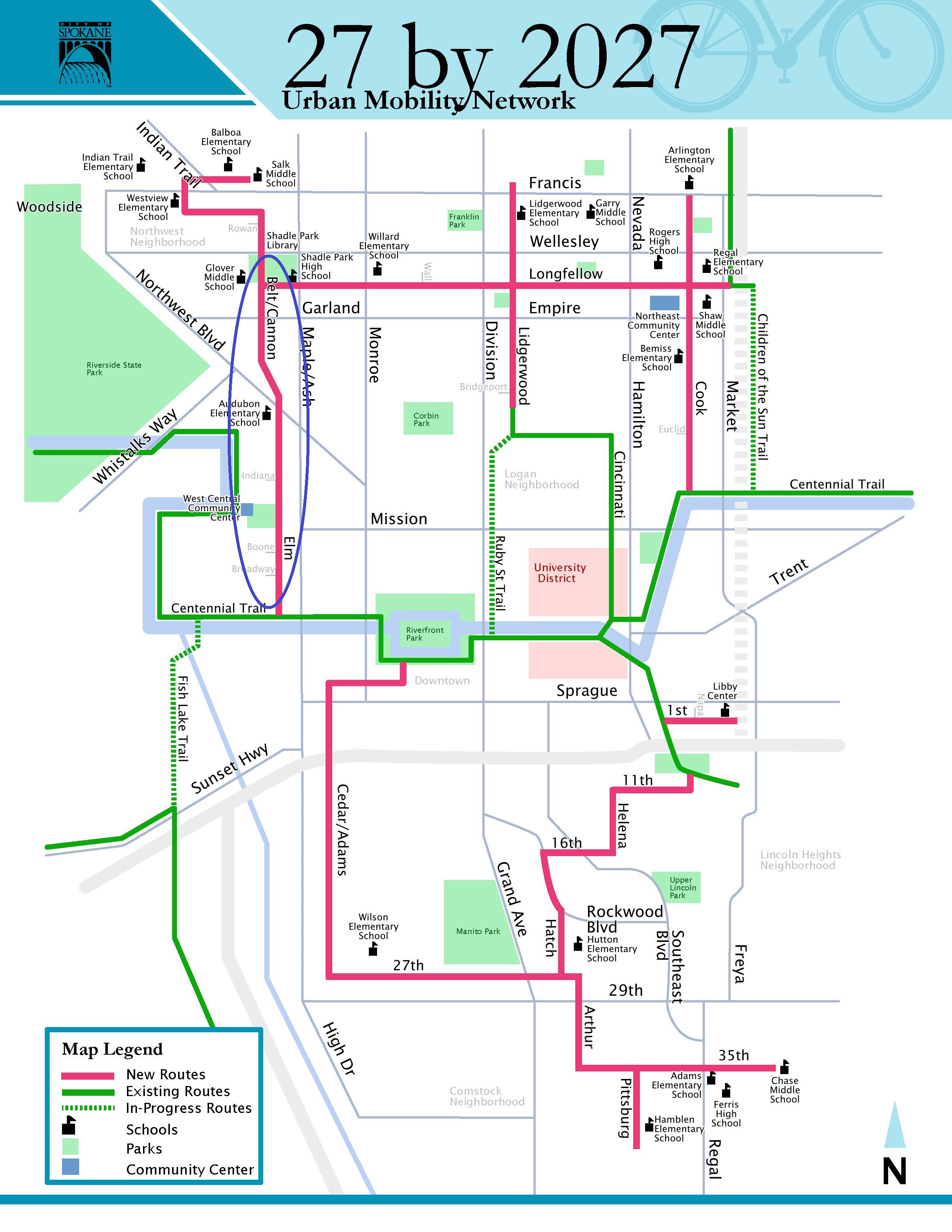
This project will create 27 miles of fully connected, safe walking and bicycling routes linking all quadrants of Spokane. This will be accomplished through multiple adaptive design interventions at strategic locations.
What is adaptive design? Also known as "quick-build" projects, these installations establish safety improvements quickly and at low cost. Temporary in nature and intent, these designs can be changed in response to different outcomes. The goal is to test responses to real-time concerns and safety issues while remaining adaptable to changing conditions.
Examples include installing channelizers to create safe street crossings for walking and bicycling or establish corner curb extensions to reduce crossing distances and slow traffic speeds.
 Conceptual Map of Future Bike Network
Click HERE to see a larger format PDF.
2025 Projects
The 27 x 2027 project begins in 2025 with installations from the Centennial Trail up Elm Street and Belt Street to the Shadle Park district center. Project elements include crossing improvements for walking and bicycling at Broadway Avenue and Boone Avenue, wayfinding markings to help with route navigation, and protected bike lanes along busier sections of the route.
Elm Street
Treatments at Broadway Avenue and Boone Avenue will enhance crossing safety along Belt Street. These crossing treatments will include installation of striping and channelizers to shorten crossing distances for walking and bicycling, while bringing greater attention to these crossing locations, enhancing the visibility of these crossings to people driving on both streets.
 Graphic 1: Draft Concept for Elm Street at Boone Avenue

Graphic 2: Draft Concept for Elm Street at Broadway Avenue
Belt Street
A scheduled resurfacing of Belt Street from Garland Avenue to Wellesley Avenue provides the City with an opportunity to install a two-way protected bike lane on the east side of Belt Street.. The project will reduce crossing distances to improve safety for walking, add protected bike lanes to improve safety for people bicycling, and adjust lane widths to manage vehicle speeds and improve safety for all road users, including people driving as well as walking and bicycling.
This project provides an opportunity to test adaptive design treatments and layouts while establishing an important link in the 27 x 2027 network, connecting into the heart of Shadle Park.
The project consists of:
1. Grinding off existing asphalt and striping,
2. Applying a new asphalt overlay to maintain street quality, and
3. Applying a new striping layout, as described below.
In accordance with the City’s Bicycle Master Plan and the City’s Complete Streets Ordinance, the new striping layout will include:
1. Adjusting lane widths to manage speed and improve safety;
2. Reducing on-street vehicle parking at select locations, and
3. Adding protected, two-way bike lanes on the east side of the street, following the layout shown on the reverse of this page for your block.
This project was approved as part of the City’s Bicycle Master Plan, Comprehensive Plan, Bicycle Priority Network, and neighborhood plans, which propose bike lanes on Belt Street in the Shadle Park commercial areas as part of a continuous north-south bike route along Belt Street and Elm Street between the Centennial Trail and Shadle Park.
Graphic 3: Draft Concept for Belt Street Cycle Track
Adaptive Design Guide
The Adaptive Design Guide will play a role in carrying out the 27 x 2027 project. This guide is a process document containing the steps and guidelines for creating and implementing Adaptive Design projects. This document will help City staff develop a process for developing fast, safe, and cost-effective projects, and assist the public in following the process and knowing when to engage.
 Flow Chart of Adaptive Design Project Development
Graphic 4: Process for developing quick-build and adaptive-design installations
Click HERE to see a larger format Project Development PDF.
Past Adaptive Design Projects
Broadway Avenue at Chestnut Street
In this pilot project, the City installed channelizers at the intersection of Broadway Avenue and Chestnut Street adjacent to Dutch Jake's Park. The project included a quick-build median to narrow crossing distances, establish a pedestrian refuge, and increase the visibility of people walking, bicycling and rolling across Broadway Avenue.

Howard Street - Mallon Ave. to Joe Albi Way
In this pilot project, the City rapidly created a public plaza with tables and chairs along Howard Street between Mallon Avenue and Joe Albi Way. The plaza sits at the north entrance of Riverfront Park by the Papillion Building and its restaurants, and across the street from the Spokane Arena Events Center, making it an ideal location for people walking through the area or visiting one of the nearby restaurants.
The plaza was made by temporarily converting the parking lane into a public seating area. The seating area is separated from car traffic by a protected bike lane that was installed at the same time. The protected bike lane enhanced the safety of the original bike lane and serves as a connection between Riverfront Park and the North Bank of Spokane.


